

GIS Solution Development
Unlocking the power of location with expert GIS solutions.
Who We Are
MapDev is a leading provider of customized geographic information system (GIS) solutions. Our team of experienced software developers and GIS professionals specializes in leveraging the ArcGIS platform to build powerful, intuitive map applications, visualizations, and analysis tools that work seamlessly across a variety of devices.
In addition to custom app development, we offer GIS data services — including data cleanup and migration, geoprocessing, spatial analysis, and support — to help your organization make the most of its location-based data.
Whether you're aiming to improve decision-making, streamline operations, or enhance the user experience, we have the skills to deliver a solution tailored to your needs. With a focus on quality, clarity, and attention to detail, MapDev is your partner for success in the world of GIS.
Services
ArcGIS Integration
We’ll make your product work seamlessly with the ArcGIS Platform—whether it’s embedding maps, syncing data, or unlocking powerful spatial tools.
Experience Builder Solutions
From custom widgets to full app rebuilds, we help you get the most out of ArcGIS Experience Builder. Still using Web AppBuilder? We can migrate and modernize your app—faster, cleaner, and future-ready.
Cross-Platform Map Apps
We build responsive, intuitive map apps that work on any device—desktop, tablet, or mobile. Whether it's for public engagement or internal tools, your maps will look great and perform everywhere.
Need a native app? We can do that too.
.NET Development on Azure
We build reliable, scalable backends using .NET on the Azure platform—so your apps have the power they need behind the scenes.
Real Estate Transaction Standard (RETS)
Proven experience building custom real estate solutions with RETS—maps, feeds, and integrations included.
GIS Data Services
We handle geoprocessing, data cleanup and migration, attribute editing, format conversion—so your data is ready for apps, dashboards, and decision-making.
Spatial Analysis
We turn spatial data into decisions. From site selection and proximity analysis to overlays and spatial modeling, we help answer the “where” and “why” behind your data.
Other?
If you’ve got something different in mind, we’re always up for a challenge—custom is our default. Let’s chat.
Who we work with


Projects
Most of our projects are enterprise systems not available to the public. But here are a few we can share...

ReMap Mobile App
A real estate listing app available on Android and iOS. This app brings together a lot of open source data from various open data portals. Advanced filtering, favourites, push notifications, measure... lots of great features.
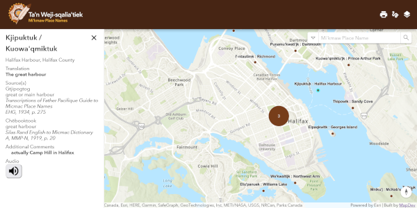
Mi'kmaw Place Names Digital Atlas
MapDev created the web mapping application for the Mi'kmaw Place Names Digital Atlas. There is also a backend system that allows contributers to easily add new placenames which are reviewed prior to being released on the map.
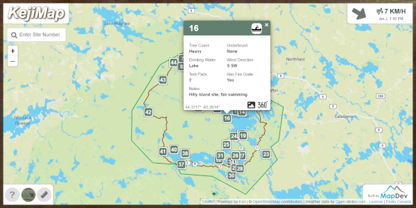
KejiMap
This interactive web map shows details of the backcountry at Kejimkujik National Park. This was one of our "just because" apps. We built it because a few people on our team really enjoy the park and wanted to create a map for ourselves and others to enjoy.
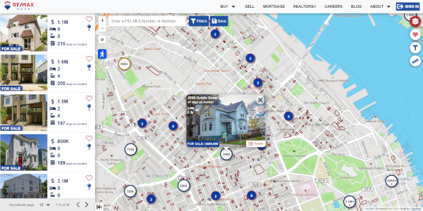
RE/MAX Nova Listings Map
An interactive web mapping application to explore real estate listings in Nova Scotia. This app is packed full of data and great features.
Our Process
1. Connect
We start by getting to know your project, your goals, and what success looks like—for you and your users.
2. Design
Through sketching, wireframing, and collaboration, we refine the solution together until we land on something clear and ready to build. When needed, our technicians assess data quality and spatial requirements early in the process.
3. Develop
We build iteratively with constant feedback—so what we deliver is exactly what you need, not just what we guessed. As developers focus on the build, our technicians prepare, analyze, and validate the spatial data behind it.
4. Keep it going
After launch, we stay involved. Whether it's updates, support, or planning what's next, we're here to keep your solution working and evolving.